The Town has $20.9
million currently available in COVID relief funds. This document proposes how
to allocate that federal funding, with some recommended immediate expenditures
and some over the course of the remainder of FY22. Some funding is intended to cover
salary expenses through FY23 for new staff.
This document
is intended as a framework for discussion at the special Town Council meeting
of Jan. 31, 2022. These priorities are only the opinion of Councilor Gordon as
a framework for discussion. Other Councilors might present their own priorities
as a starting point, as might the Town Manager.
Each item
indicates how the proposal is tied to COVID relief. The basic language of ARPA
is flexible and generalized: “The American Rescue Plan Act of 2021 provides a
substantial infusion of resources to eligible state, local, territorial, and
tribal governments to help turn the tide on the pandemic, address its economic
fallout, and lay the foundation for a strong and equitable recovery.”[1]
Specific page references from Randolph's ARPA
consultant report[2]
are excerpted and highlighted in brown.
Priority 1: $7.5 million for Drinking Water: ARPA allows funding for “necessary investments
in water, sewer, or broadband infrastructure.”[3]
Randolph has immediate and long-term needs in this area:
1A. $5 million set aside for the new water treatment plant, to allow zero increase
in water bills in FY23.
p. 15, Eligible under Clean Water State Revolving Fund: Construction
of publicly owned treatment works
1B. $0.5 million to investigate PFAS sources immediately, and install interim PFAS
filters[4]
as soon as possible.
p. 15, Eligible under Clean Water State Revolving Fund: nonpoint
source pollution management program
1C. $2 million to purchase equipment to replace “dead-end water mains” with
looped pipes, to reduce brown water.
p. 15, Eligible under Drinking Water State Revolving Fund: Facilities
to improve drinking water quality
Priority 2: $7.5 million
for the Hiring Crisis and pandemic recovery: The pandemic has made hiring new staff
difficult, and made retaining existing staff challenging too. The Town needs
additional new staff to invest in our recovery from the pandemic and our future
growth. One-time hiring bonuses (as opposed to salary increases for new
positions) can move us past our immediate needs without burdening future years’
budgets. Hiring bonuses to be paid after 6 months on the job. 2D/2E/2F address
other pandemic-based crises with one-time spending.
2A. $2 million allocated for advertising and recruiting for the following new Town
staff positions: Fire Chief; Assistant Town Manager; Treasurer/Collector; Hiring
and Staff Retention Manager; Business Development Officer; three new DPW staff
positions (2B above); four new Randolph van drivers (2C above).
p. 13, “Premium Pay” with “higher scrutiny for provision of
premium pay to higher earners” [written justification]
2B. $2 million allocated for existing staff to all get comparable retention
bonuses at the end of 2022.
p. 13, under Eligible Workers: Any work performed by an employee
of a local government [as “Premium Pay”]
2C. $0.5 million for the Randolph Public Schools to assist in the School
Committee doing the same for teachers.
p. 12, under Eligible Workers: Educational work [as “Premium Pay”].
This $0.5M would be from the Town; RHS has another $1M available under a new
bequest awaiting their allocation.
2D. $1 million for a rent and mortgage relief fund: We passed a resolution on
this last year -- Boston does it already.
p. 5, under “Emergency Housing Assistance”: Eligible services include
rental arrears and mortgage payment assistance; and p. 4 specialized services
for individuals with disabilities or seniors
2E. $1 million for a “Revolving Fund” for loans to small business, to attract new
businesses as we wind down from the pandemic; to be administered and publicized
by the Business Development Officer in 2A.
p. 8, under “Impact to Small Businesses”: Factors include lost
revenue or increased costs
2F. $0.5 million for Resiliency Fund: COVID Benefit Navigator and for a childcare
assistance fund
p. 3, under “Assistance to Households”: Uses include: Assistance
applying for public benefits or services; programs or services that mitigate impacts
childcare and early learning services.
2G. $0.5 million for re-opening RICC and public facilities: Convert community
center back from vax site.
2G is not explicitly eligible -- not cited anywhere in Anser
report -- but of course converting TO a vaccination and testing site is
covered, and I don't think converting back would be an issue.
Priority 3: $1
million for Local Transportation: With more residents working from home during the pandemic, ARPA allows
funding “to support the nation’s public transportation systems.”[5]
3A, 3B, 3C seem ineligible despite federal DOT guidance in
footnote 5. This must await Infrastructure funding, or in the "$10 million
eligible for replacement of lost municipal tax revenue," which disallows only
applying funds to tax cute, pensions, or debt payoff.
3A. $2 million to purchase equipment and fund several full street repaving
projects, to increase our repaving rate.
3B. $0.5 million to hire three new DPW staff for pothole repair and other work;
to fund new salary through FY23.
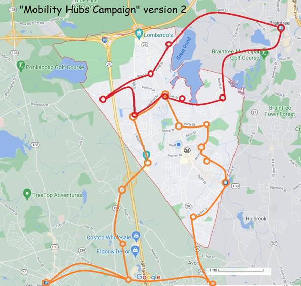
3C. $1.5 million to purchase vans and establish “Randolph Shuttle” routes to
nearby transportation hubs (map below).
3D. $1 million to immediately add traffic features -- sidewalks and traffic
lights -- planned in early Traffic Study phases.
p. 7, under “Investments in Neighborhoods”: eligible uses such
as sidewalks and streetlights.
Priority 4: $1 million for Outdoor Recreation: The Randolph Master Plan calls for better
pedestrian access to parks; the pandemic makes improved outdoor recreation a
necessity and also addresses mobility access as outlined in the Randolph Community
Wellness Plan.
4A. $0.5 million for a series of boardwalks (like at Powers Farm) for pedestrian
access across swampy areas, allowing residents to walk to work or walk to
nearby transit lines. For example, a boardwalk across the Great Bear Swamp would
connect the Bittersweet apartments to the Patten Drive business area -- red
dashed lines on map below.
p. 7, under “Investments in Neighborhoods”: eligible uses such
as parks, green spaces, and pedestrian safety features
4B. $0.5 million for a series of parking places at existing parks that have
limited pedestrian access, to replace “No Parking” and “No Dumping” signs. For
example, where can one park to enter the South Randolph Conservation Area?
p. 7, under “Investments in Neighborhoods”: eligible uses such
as projects to revitalize public spaces
Summary with eligibility notes:
Priority 1: $7.5 million for Drinking Water: all eligible
Priority 2: $7.5 million for the Hiring Crisis and pandemic
recovery: all eligible with some
written justification required for Premium Pay to higher earners in town government.
Priority 3: $4 million for Local Transportation:
Street repaving and
Randolph Shuttle are ineligible
Priority 3D. $1 million: Sidewalk and
streetlight projects are eligible
Priority 4: $1 million for Outdoor Recreation: all eligible
|
Randolph Red Route:
|
|
Randolph Orange Route:
|
Reducing PFAS in Drinking Water with Treatment
Technologies
Published August 23, 2018 (EPA) -- excerpts…
EPA
researchers have been studying a variety of technologies at bench-, pilot-, and
full-scale levels to determine which methods work best to remove PFAS from
drinking water….
Granulated
Activated Carbon (GAC)
Activated carbon treatment is
the most studied treatment for PFAS removal. Activated carbon is commonly used
to adsorb natural organic compounds, taste and odor compounds, and synthetic
organic chemicals in drinking water treatment systems. Adsorption is both the
physical and chemical process of accumulating a substance, such as PFAS, at the
interface between liquid and solids phases. Activated carbon is an effective
adsorbent because it is a highly porous material and provides a large surface
area to which contaminants may adsorb. Activated carbon (GAC) is made from
organic materials with high carbon contents such as wood, lignite, and coal;
and is often used in granular form called granular activated carbon (GAC).
GAC has been shown to
effectively remove PFAS from drinking water when it is used in a flow through
filter mode after particulates have already been removed. EPA researcher Thomas
Speth says, “GAC can be 100 percent effective for a period of time, depending
on the type of carbon used, the depth of the bed of carbon, flow rate of the
water, the specific PFAS you need to remove, temperature, and the degree and
type of organic matter as well as other contaminants, or constituents, in the
water.”
For example, GAC works well
on longer-chain PFAS like PFOA and PFOS, but shorter chain PFAS like Perfluorobutanesulfonic
acid (PFBS) and Perfluorobutyrate (PFBA) do not adsorb as well.
Powdered Activated
Carbon (PAC)
Another type of activated
carbon treatment is powdered activated carbon (PAC) which is the same material
as GAC, but it is smaller in size, powder like. Because of the small particle
size, PAC cannot be used in a flow through bed, but can be added directly to
the water and then removed with the other natural particulates in the
clarification stage (conventional water treatment or low-pressure membranes -
microfiltration or ultrafiltration). Used in this way, PAC is not as efficient
or economical as GAC at removing PFAS. Speth says, “Even at very high PAC doses
with the very best carbon, it is unlikely to remove a high percentage PFAS;
however, it can be used for modest percent removals. If used, however, there is
an additional problem with what to do with the sludge that contains adsorbed
PFAS.”
Jesse Gordon notes: The best PFAS water treatment is
"reverse osmosis," which we will install with our new water treatment
in a couple of years. That method is detailed in the EPA article, but is not
available in the current Randolph/Holbrook water treatment plant due to space
considerations. So at issue is, "What do we do for
the interim years?" The GAC and PAC methods can reduce PFAS in the interim
period -- not perfect, but quick.
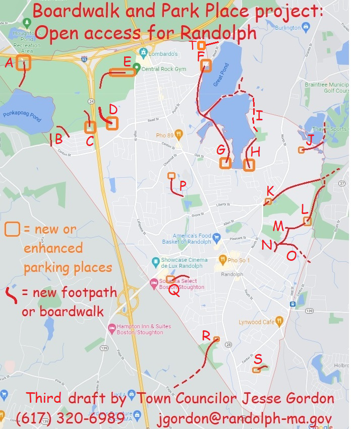
Description of each proposed Boardwalk and/or Parking Place:
A.
Exit 3 on Interstate
93: Already a parking area here; I proposed to DCR to expand it as part of Ponkapoag
Pond project and they likely will do so. The Town could add our own signage linking
to other Randolph access points.
B.
The Town has several
"right-of-way" access points into the Blue Hills State Park (town
land off Sunset Drive). I proposed to DCR opening these for pedestrians -- it's
our responsibility on the Town side.
C.
At the end of Turner
Drive is a right-of-way that leads directly to a DCR hiking trail. We could add
signs and a path to that hiking trail, and create a few parking spots. I proposed
this to DCR too, but it's unlikely they'll participate.
D.
The Donovan School has
a hiking trail entrance at the back of the parking lot (off of Reed Street).
There's a sign on Reed Street but none in the parking lot -- we could define parking
rules and add signs.
E.
There's a street
called "Middle Street" off High Street, which is closed by DCR with a
gate. The street extends several hundred yards to the abandoned missile site but
also to several hiking trails. The entire street could be opened as a parking
area.
F.
The north end of the
Reservoir Walk (off Pond Street) has a few parking spots, but needs signs so
people know that it's legal. And some signs indicating hiking destinations (including
a hidden workout area near this spot!)
G.
There's another
workout area off of Oak Street that has no parking. Let's add a few spots so people
can use this, It also leads to a the same Reservoir
Walk trail, but needs signs because it's hidden.
H.
Off Oak Street on the east
side of the reservoir is another section of the Reservoir Walk, with some
parking spots that look like they're illegal. Needs signs saying what's legal
and encouraging hiking.
I.
The Fin-Fur-Feather
conservation area is hidden in the woods -- it needs signage welcoming in pedestrians,
including hidden entrances on Isabell Circle and State Street. I've discussed
with Braintree residents and representatives continuing the Reservoir Walk on
their side -- it's very rough but you CAN walk around!
J.
The Richardi Reservoir
spans the Randolph-Braintree border like the main reservoir does -- and it
could also have a Reservoir Walk. Possible entry points include Meadow Lane,
Lincoln Ave, and Randolph Road -- some right-of-way's
already exist.
K.
There's a "rail
trail" that extends from Depot Street to North Street and then peters out
east of North Street. But the rail trail is there -- we just have to clear it
and put up some signs. It even has a parking area on the east side of North St
near Liberty Street. This rail-trail leads into Braintree and could connect
directly to the MBTA station.
L.
At the back of Teed Drive
and Chief's Way (at the FedEx building) is a very large swampy area called the
"South Street Conservation Area" which extends into Braintree and
Holbrook. We could make parking spots on Chief's Way, and make boardwalks
through the swampy areas to connect to several points.
M.
Possible entry points include:
Cochato Park/Roycroft Drive, Kingcrest Terrace, and Seton Way (St Mary's
school). Boardwalks across the Conservation Area would provide pedestrian
access from several neighborhoods to the MBTA #230 bus, which runs from Braintree
to Holbrook just east of the Conservation Area.
N.
The JFK Elementary
School property abuts this same swampy area and could be connected by a boardwalk.
O.
There is a bridge over
the railroad tracks from Randolph to Holbrook -- a street called Kelleway Drive
which currently has access only from Holbrook. Making a boardwalk connection to
Kelleway Drive would allow pedestrian access to the Commuter Rail station, and a
bicycle route to the Braintree MBTA station.
P.
The Town of Randolph
recently acquired a new parcel of Powers Farm abutting Niles Road. A boardwalk
through the swampy area could provide pedestrian access via Chestnut Circle. A
new parking area accessible from Chestnut Circle could provide much-needed overflow
parking for Powers Farm events.
Q.
The south end of Thomas
Patten Drive (past the post office) abuts a swampy area that could have a
boardwalk of only a couple hundred yards length, to Bittersweet Lane. A small parking
area could provide an entry point with signs. The boardwalk would allow
pedestrian access from the nearby apartment complexes to the many workplaces on
the other side: the hotels; the theater; and so on -- reducing traffic for
employees and customers.
R.
The Lokitis Conservation
Area abuts Stoughton Street and L'Heireux Circle but has no marked entrances. A
few parking spots on Stoughton Street, and a sign, would allow access through
the Conservation Area to Avon -- it's actually walkable distance to D. W.
Field! It's the Avon Industrial Park on the other side -- we'd need to work
with Avon to put up some signs.
S.
The South Randolph
Conservation Area abuts North Sherwood Ave., north Richmond Ave., and North
Glenway Ave -- but has no visible access points. Creating a few parking spots
and a hiking trail or boardwalk would allow recreational usage instead of just
a lot of "No Dumping" signs. The Randolph Master Plan recommends pedestrian-accessible
parks in South Randolph -- this could be one, right away!
T.
Connecting Pacella
Park Drive with the old Rt 128 paved hiking trail in Braintree